At first glance, the Luberon appears as a long, bluish ridge between the Durance River and the Vaucluse Mountains. On our map of the Luberon, this mountain range stretches 75 km from Cavaillon to Manosque and Forcalquier, straddling the departments of Vaucluse and Alpes-de-Haute-Provence.
The Lourmarin valley separates the Petit Luberon, to the west, from the Grand Luberon, to the east. Its highest point, the Mourre Nègre, rises to an altitude of 1,125 m.
On the northern slope, the Apt region is home to Gordes, Roussillon, and Ménerbes, all ranked among the most beautiful villages in France. On the southern slope, Lourmarin and Ansouis overlook the vineyards.
This tourist map of the regional nature park helps you locate the villages of the Luberon, identify points of interest, and plan your trip.
Tourist map of the Luberon
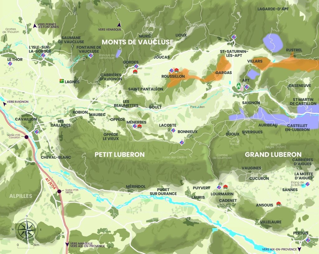
If you would like to download a PDF or JPEG of this map with villages, you can click the link below:
Interactive map of the Luberon
If you need to zoom in on a specific village, we have an interactive map below.
Your questions about these maps
We’ve received several questions from you about the geography of the Luberon. Here are our answers to your most frequently asked questions.
Where is the Luberon on the map?
The Luberon lies in southeastern France, in the heart of the Provence-Alpes-Côte d'Azur region. On a map of the Luberon, start by looking at the southern part of the Vaucluse department. To the east, the range extends into the Alpes-de-Haute-Provence.
This area is protected by the Luberon Regional Nature Park, created in 1977. It covers about 185,000 hectares (457,000 acres) and brings together nearly 80 towns and villages. To the south, the Durance River marks its border for more than 105 km (65 miles), between Lurs and Cavaillon. To the north, the park takes in part of the Monts de Vaucluse.
Now look at the towns around the range. Cavaillon guards the western gateway. Apt sits in the center, in the Calavon valley. Manosque and Forcalquier mark the east, and Pertuis the south.
The major cities are close by. Avignon is about 50 km (30 miles) from Apt. Aix-en-Provence is about 35 km (22 miles) from Lourmarin, and Marseille about 80 km (50 miles). L'Isle-sur-la-Sorgue and Fontaine-de-Vaucluse sit on the park's northwestern edge.
With these landmarks in mind, the map becomes easy to read. Next come the villages that made the Luberon famous.
Which villages should you visit in the Luberon?
Visiting the Luberon means going from village to village. Five of them hold the Most Beautiful Villages of France label: Gordes, Roussillon, Ménerbes, Lourmarin, and Ansouis. Each has its own personality, its own light, and its own view.
Gordes clings to the edge of the Monts de Vaucluse, facing the valley. Its dry-stone houses rise in tiers up to the castle. A few kilometers away, the Sénanque Abbey draws photographers during lavender season. Arrive early in the morning to enjoy the village in peace.
Roussillon changes with the time of day. The village stands on one of the largest ochre deposits in the world. Its red, orange, and yellow facades echo the cliffs around it. From its heights, you can see Mont Ventoux.
On the northern slope of the Petit Luberon, Ménerbes rises on its spur like the bow of a ship. The painter Nicolas de Staël and Dora Maar both lived here. Directly opposite, Bonnieux climbs up to its 12th-century upper church, reached by 86 steps. Its Friday morning market is one of the most pleasant in the area.
On the other side of the range, Lourmarin lives around its Renaissance castle. Albert Camus and Henri Bosco are buried in its cemetery. Finally, Ansouis overlooks the southern Luberon from its rock and castle.
These villages invite you to venture beyond their streets. The Luberon is also best enjoyed outdoors and at the table.
What activities can you do in the Luberon?
The Luberon has an activity for every mood. Hiking comes first. The cheminsdesparcs.fr website, run by the regional parks, lists 79 routes in the Luberon. You will find short walks as well as full-day loops.
Cycling appeals to more and more visitors. The Calavon cycle route follows the former railway line between Apt and Cavaillon. It passes the Pont Julien, which is reserved for pedestrians and cyclists. The steeper terrain of the range attracts mountain bikers.
Exploring the vineyards is a big part of any stay. Luberon wine has its own AOC (protected designation of origin). Estates often open their cellars for tastings, especially on the southern slope. Remember to book the most popular visits ahead of time.
Food completes the picture. Apt is known for its candied fruit. Markets set the rhythm of the week: Apt on Saturday morning, Lourmarin and Bonnieux on Friday morning. On Sunday, L'Isle-sur-la-Sorgue adds its market and antique dealers.
Cultural tourism is not left behind. The Maison du Parc in Apt houses a geology museum. To organize all these outings, a good map quickly becomes essential.
How can you get a map of the Luberon?
You can get a map of the Luberon in several ways. The easiest one is right on this page. To download the Luberon maps here, use the “Download the map” button above. That way, you keep the map on your phone, even without a signal.
Prefer a paper map? The Luberon Park has published a discovery map of the area. Printed on both sides, it shows the main points of interest, the villages, local products, and outdoor sports. It is available on request at the Maison du Parc and at local tourist offices.
The Maison du Parc is located at 60, place Jean-Jaurès, in the historic center of Apt. It occupies an 18th-century mansion. It is open Monday, Tuesday, and Thursday from 2:00 to 5:30 p.m., and Wednesday from 9:00 a.m. to 12:30 p.m. and 2:00 to 5:30 p.m. Check these hours before your visit by calling +33 4 90 04 42 00.
Its shop also sells hiking maps and trail guides. The park also publishes a geotourism map, in PDF and paper versions. It features about sixty geosites. Ask for your map on site or by phone.
Map in hand, you only need to choose what you want to see. There is no shortage of points of interest.
What are the points of interest in the Luberon?
The Luberon's points of interest are split between natural sites and heritage landmarks. Start with the ochres. The Ochre Trail in Roussillon crosses former quarries in vivid colors. Farther east, the Colorado Provençal in Rustrel offers even wilder scenery.
You can also discover ochre underground. In Gargas, the Bruoux mines have more than 40 km (25 miles) of tunnels. About 650 meters (2,130 feet) are open to visitors. The cool air is welcome in the middle of summer.
The Cedar Forest covers about 250 hectares (620 acres) on the ridge of the Petit Luberon, south of Bonnieux. Part of the site is accessible to people with disabilities. In summer, access to the hills may be restricted due to wildfire risk. Check the daily guidelines before you set out.
For heritage, the Pont Julien is worth a stop. This three-arched Roman bridge crosses the Calavon, along the route of the Via Domitia. It has been listed as a historic monument since 1914. The Sénanque Abbey, the Château de Lourmarin, and the Château d'Ansouis round out a rich visit.
Oppède-le-Vieux also keeps the ruins of its fortress above the village. To understand why these sites are so varied, take a closer look at the terrain.
What is the geography of the Luberon?
The geography of the Luberon is organized around a mountain range running west to east. It stretches 75 km (47 miles), from Cavaillon to Forcalquier. This limestone barrier shapes the whole area. It separates the Calavon valley to the north from the Durance valley to the south.
The Combe de Lourmarin cuts the range in two. The Petit Luberon lies to the west. The higher Grand Luberon rises to the east. Its highest point, the Mourre Nègre, reaches 1,125 meters (3,691 feet).
The northern slope faces the Calavon valley and the Monts de Vaucluse. Farther away, Mont Ventoux closes the horizon. The southern slope descends toward the Durance, among vineyards and orchards. Beyond the Grand Luberon, the eastern Luberon reaches the Manosque area.
This terrain sits where Mediterranean and mountain climates meet. It explains the great variety of landscapes and natural habitats. UNESCO recognized the area as a biosphere reserve in 1997. The Luberon is also a UNESCO Global Geopark.
This unique setting makes every itinerary different. All that remains is to plan your days well.
How should you plan a trip to the Luberon?
To plan your stay, start with its length. Allow at least three days to see the highlights without rushing. A week gives you time to hike and browse the markets. A car is essential to get from one village to the next.
The tourist map helps you build a logical itinerary. Spend one day north of the range: Gordes, Sénanque, and Roussillon. Save the next for the Petit Luberon: Oppède-le-Vieux, Ménerbes, Lacoste, and Bonnieux. Finish in the south, with the Combe de Lourmarin, Lourmarin, and Ansouis.
Then choose your base. Apt offers a central location. Hotels in Gordes, Bonnieux, or Lourmarin let you enjoy the villages in the evening, once the crowds have left. In high season, book your accommodation several months in advance.
Keep the calendar in mind too. Spring and fall bring mild temperatures and fewer visitors. Lavender usually blooms from mid-June to mid-July around Sénanque. In summer, parking becomes difficult in the most popular villages.
To get there, the Avignon TGV station and Marseille-Provence airport are the most convenient gateways. Keep this complete guide close at hand to choose your activities day by day.